Thursday, September 29, 2016

Madavoorpara Cave: Hindu Rock cut Temple near Thiruvananthapuram, Kerala


Madavoor_Para_Cave_Temple.jpg (3600×2160)

DSC_7231.JPG (1278×855)

62_big.jpg (500×375)

51_big.jpg (240×180)

madavoorpara.jpg (960×1280)

Madavoorpara rock-cut cave temple is situated in Madavoopara village, Kazhakuttam taluk, Thiruvananthapuram district, Kerala, India PIN 695587. It is forming part of Ayiroorppara Panchayat and located between Pothencode and Chempazhanthy.. The cave is located 15 km towards North from District head quarters Thiruvananthapuram.  Madavoopara is geographically located at latitude  8 ° 35′ North and longitude 76 ° 59′ E' and the altitude / elevation is 64 m (210 ft). The rock cut cave temple was owned by the Chenkottukonam Ashram and from 1960 the premises is protected by the State Archaeological Department. It is one of the two rock cut caves in Thiruvananthapuram district.

Architecture

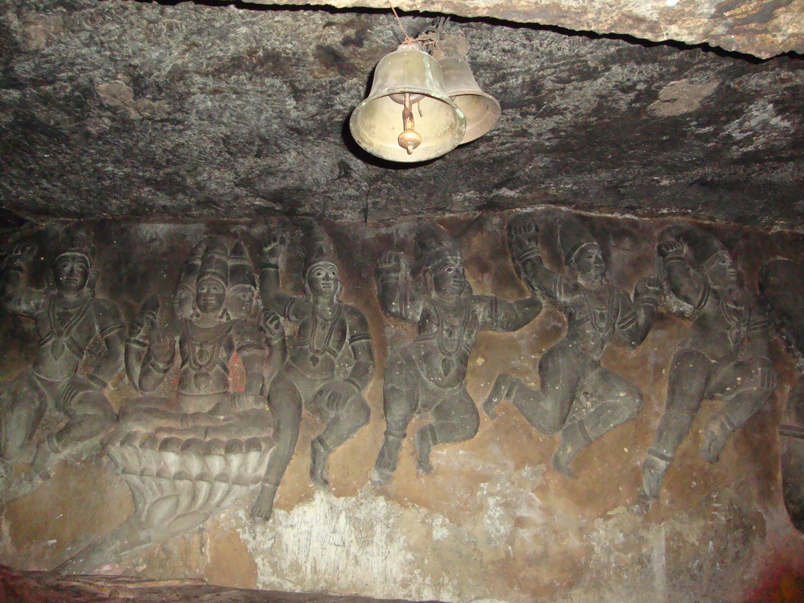
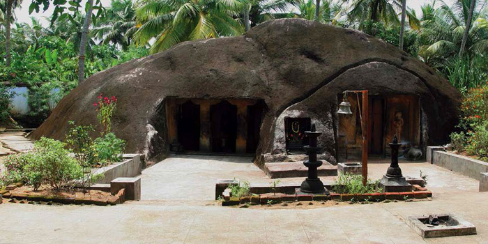
The rock cut cave excavated on the solid rock face on top of the hillock. To reach the cave, you have to climb more than 200 steps. The flight of thirty three steps, sculpted on the rock, leads one to the square-shaped cave temple. The rock cut cave is dedicated to Lord Shiva. The images of Lord Shiva and Lord Ganapathy sculpted on the right side of the wall. On the left side there is an image of the local chieftain.  

History

Buddhism and Jainism spread in Kerala around 3rd century A.D. Jainism continued to have strong hold for about 700 years in south Kerala region.  The earliest Buddhist rock-cut cave abodes were built for Buddhist missionaries (monks) by the kings and traders on the busy international trading routes. Vikramaditya Varaguna (885–925), the Ay king popularly known as Ashokan in Kerala, ruled parts of south Kerala. The Paliyam Copper Plate "Sreemoolavasam cheppedukal"  was issued by this king in the fifteenth year of his rule (925 AD). The plate describe Varagunan as "vrishnikulajathan," a Buddha devotee.   The copper plate bears the evidence of the patronage extended by the ruler i.e., the donation of land to Thirumoolavadam (Sreemoolavasam), to Buddhist missionary. Buddhism was held in the highest respect and veneration by this ruler. The copper plate includes the invocation phrases like 'Buddha' and 'Dharma.' Till 1000 A.D. Buddhists continued to enjoy royal patronage . 

Hindu Revivalism in 800-1000 A.D. gradually get rid of Buddhism from Kerala. It is believed that many Buddhists and Jain shrines were converted into Hindu temples. Madavoorpara is an ancient one dating back to 850 A.D. According to one theory the rock-cut cave could have been built for Buddhist monks and another theory gives this credit to Jain monks. This temple, which resembles the ancient cave temples of the Jains,   

Inscription

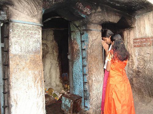
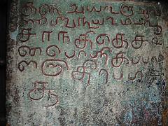
There is an ancient vattezhuthu inscription near the shrine.

Tourist Attraction

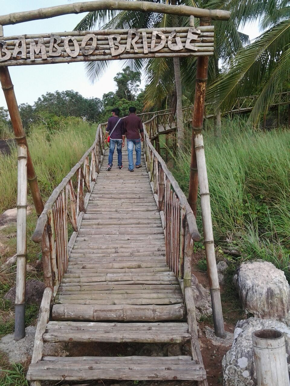
The lone Madavoorpara cave is located amidst rubber plantations and hence less explored destination till recent past. The local media, state tourism and the State Archaeological Department have initiated steps to attract tourists and locals. A small park and a 101 mt long bamboo bridge have been formed by he State Archaeological Department. The panoramic view from atop the hillock is an amazing experience.

'Ganga Theertham' the holy pond receives water from the perennial stream. Shivratri is the main annual festival celebrated in this cave temple and this event attracts thousands of devotees from far and near.

How to get there?

By road: You may take the Chempazhanthi-Potherncode route to Madavoorpara from Sreekaryam. You will reach Kattayikonam after 7 km. Take note of the Madavoorpara temple sign board on your right. You can also take the alternate route i.e., Powdikonam-Pothencode route from Sreekaryam. Drive  8 km to reach Santhipuram and divert left turn and proceed 2 km further to reach the site. There is an advantage of preferring this route i.e., you  don't have to climb up the rock.

Nearest Railway station: Kazhakuttam Railway station , Kaniyapuram Railway station are the very nearby railway stations to Madavoorpara. However Thiruvananthapuram Central Railway station is city railway station.

Reference
  1. Madavoorpara Cave Temple http://www.techmodi.com/demo/mygod/temples/MTcw/temples_detail
    Madavoorpara Siva Temple. C.P.R. Environmental Education Centre, Chennai
  2. Paliyam Copper Plate. Kerala culture.org
  3. Rock of Ages The Hindu March 27, 2015
  4. Sunday visit to Madavoorpara Rock cut temple in Trivandrum. Travelogues of a Compulsive Roamer (http://ranjithsudhakaran.blogspot.in/)
  5. Temples of Thiruvananthapuram. Kerala Windows.net  (http://www.keralawindow.net/templesoftrivandrum.htm)

YouTube
Madavoorpara Tourism. Madavoorpara Rock Cut Temple. Kattaikonam, Chenkottukonam, Trivandrum by Video Strawberry

Wednesday, September 21, 2016

Thrikkakkudy Cave: Hindu Rock-cut temple, Kaviyoor near Pathanamthitta, Kerala

hqdefault.jpg (480×360)


place3.jpg (432×432)

kaviyoor-rock.jpg.image.784.410.jpg (784×410)

thekkekudi-cave-temple.jpg (502×312)

Thrikkakudi rock cut cave temple is located about one km. north-east of Kaviyoor village, Thiruvalla taluk, Pathanamthitta district, Kerala, India PIN 689582.  The rock cut cave is located at a distance of 29 km from Pathanamthitta and 6 km from Thiruvalla, The meaning of the village name is like this: Thiru - kal - kudy’ that means - ‘sacred dwelling place in rock.’ The cave temple was renovated by Travancore Devaswom Board (TDB) and the board maintains with one daily morning pooja rituals. 

Kaviyur, a village panchayat, located on the western bank of the river Manimala, was a part of Nanruzhai Nadu which had its capital in what is now Thrikkodithanam, 9 km west of Kaviyoor. The Mahadeva temple of Kaviyoor,  built in 10th century A.D, is considered as one of the ancient Shiva (Mahadeva) temples in Kerala. Inscription dated 950 A.D. speak about gifts offered to this temple. The village  is one of the ancient 64 brahmin settlements of Kerala. The geographical coordinates Kaviyoor is Latitude 9°23′0″North (9.3920848)  and Longitude 76°36′0″East (76.6192022) and the elevation / altitude is from 8m to 61m.

The south facing Thrikkakudi rock cut cave consists of a facade, a rectangular mukha-mandapam and a sanctum. It is very skillfully cut into dome shaped roof. The plinth is plain and the cave floor little higher in level from the ground floor. A flight of four steps leads to the mukha-mandapam. The facade consists of two massive pillars in the middle and pilaster on both ends with the features of square, octagonal kattu and square. The walls are simple and plain with six foot high floor. The rough rock brow is bereft of any curved cornice moulding called 'kapota' (overhanging cornice) or drip line for rainwater.

The temple dedicated to Lord Shiva. The ten foot high and seven-foot square sanctum houses 3 feet tall Shiva lingam. The bas relief image at the door way represents Bhima, the Pandava prince of Mahabharatha.  Also there are bas relifs of Lord Ganapathi and the sage. The sanctum is guarded by imposing bas relief images of Dwarapalakas. The niches, on  the outer wall on either side of the entrance of the sanctum, houses these Dwarapalakas.. It is inferred by scholars that this cave temple was constructed in the Pallava architectural style and may be datable to 8th century. The natural pond amidst two rocks is another attraction. The rock-cut monument is protected by the Archaeological Department.

One version of the legend says that the rock cut monument was built by demons within one night. It is also believed that Lord Shiva and Hanuman of Kaviyur Mahadeva temple appeared here to interrupt the task of temple construction. The demons had to flee to save their lives. Another version says that the Pandavas of Mahabharatha dwelled in this cave during their exile in the forests.

In the words of Unnikrishnan, an archaeologist of repute, Thrikkakudi rock cut cave temple might have been a Buddhist vihara centuries ago. It is evident that Buddhism and Jainism flourished in this location before 10th century A.D.

Thiruvalla is well connected to other major cities of the country via regular buses. Kozhikode, Thiruvananthapuram, Kollam Kannur, Kochi , Coimbatore , Chennai, Madurai, Bangalore and Mangalore are connected from Thiruvalla through road.
Nearest Railway Station:  The town has its own Railway Station named as Thiruvalla Railway Station. It is  about 5 km from Kaviyoor.
Nearest Airport: Thiruvananthapuram International Airport, about 119 km from Pathanamthitta.

Reference

  1. Kaviyuur. Mathrubhumi (English) 31 May 2008.
  2. Kaviyoor Ente Gramam. Fa
  3. Rock-cut temple at Kaviyur, relics of a bygone age. Radhakrishnan Kuttoor. The Hindu. July 10, 2013.
  4. Remnants of a Bygone Era: Rock-Cut Temple at Kaviyur. Hithokthi.com 
  5. Thrikkakkudy temple, where time stands still. The Hindu. March 23, 2015.
YouTube videos


Friday, September 2, 2016

Kottukal Cave: Hindu Rock cut Cave Temple, Kottukal near Kollam


Kottukal-Rock-cut-Temple.jpg (700×350)

Kottukal-Rock-Cut-Cave-Temple.jpg (636×424)

Kottukal (കോട്ടക്കല്) rock cut cave, also known as Kaltrikkovil (കാലത്തിരിക്കോവിൽ) in Malayalam, is located in Ittiva (ഇട്ടിവ) village in Chadayamangalam (സദായമനഗലം) taluk in Kollam (കൊല്ലം) district, Kerala State, India PIN 691534.  Ittiva village, part of Ittiva village panchayat,  is in the border of the Kollam and Thiruvananthapuram (തിരുവനന്തപുരം) districts. This cave is located on the Thiruvananthapuram – Kottayam MC Road. The geographical coordinates of Ittiva are 8.8421200° North (Latitude) 76.864440° East (Longitude).  It has an average elevation of 52 m (170 ft). 

The name Kottukkal means carved rock in English (കൊട്ടിയ കല്ല് Kottiya Kallu in Malayalam). Kottukal rock cut cave  architecture typifies rock cut cave style of Kerala. The cave hewn out from a natural living hammock situated amidst paddy field. The hillock looks like an elephant in a sitting position. 

Architecture

The rock cut cave complex has two caves of uneven size. Both the caves are facing east. The larger cave has an almost square sanctum and pillared mukha-mandapam (rectangular hall). The rock cut façade has two massive supporting pillars. The smaller cave opens an oblong sanctum and there is no pillared mandapam. The cave-temple dedicated to Shiva. The sanctums have the monolithic Shiva lingams and the celestial bull (Nandi) idol. Another sanctum (niche) houses the image of sthanaka Hanuman (Anjaneya), the monkey god. In between the two caves there is a rectangular alcove like shrine housing the bas relief image of Lord Ganapathy (Lord Pillaiyar).  The cave temple complex also known for its well that never dries up.

History

Since the rock cut cave houses three deities Lord Shiva, Lord Ganapathy and Lord Hanuman, the name "Thrikovil" emerges. The rare association of Shiva Lingam, Nandhi and Anjaneya is seen only Kottukal and nowhere else in India such combination exists. According to some scholars the cave datable between 6th and 8th centuries A.D. Some other  historians assign the date back to 7th century A.D. Chadayamangalam named in remembrance of Nedila Paranthaka Nedumchadayan, who ruled Chadayamangalam between 6th and 7th century AD. 


The rock cut cave temple is administered by Travancore Devaswom Board and this body conducts daily pooja services. The state government of Kerala pronounced the Kottukal cave owned by Travancore Devaswom Board as the protected monument in 1966. 

How to get there?
  • Best Time to visit: December to May
  • Distance: Kottukal Rock cut Cave is located 10 km from Chadayamangalam and 8 km from Anchal. The place is 45 km away from Kollam and 65 km away from Tiruvananthapuram.
  • Nearest Bus stations; The village is connected through local bus service from Chadayamangalam and Anchal.
  • Nearest railway station: No railway station near to Ittiva in less than 10 km. Kollam (Quilon) Jn Rail Way Station is located 38 km away from Ittiva.  Punalur station 19 km; Thenmalai 23 km; Ottakkal 22 km.
  • Nearest airport: Trivandrum International Airport, about 60 km
Reference
  1. Kottukkal Rock Cave Temple GUHA Kshethram. Facebook. May 8, 2015 
  2. Kottukal Rock Cut Cave Temple. Mahrubhumi (English). May 31, 2008
  3. Kottukal Rock Cut Cave Temple. Tapioca.co.in
  4. The Cave Temple at Kottukal, Kollam. Kerala Tourism.org
  5. കോട്ടുക്കല്‍ ഗുഹാക്ഷേത്രം , അഞ്ചല്‍, കൊല്ലം (http://kudukka.com/coin123)

YouTube
Kottukkal cave temple by santhosh kottukkal


Tuesday, August 30, 2016

Akkanna Madanna Caves: Hindu Rock cut Cave Temple at Vijayawada


Akkanna-madanna_caves,_vijayawada_(19).JPG (4608×2592)


256px-Akkanna_Madanna_caves_Indrakeeladri_Vijayawada03.jpg (256×188)

Akkanna-madanna_caves,_vijayawada_(18).JPG (4608×2592)

Akkanna_Madanna_Rock_cut_Caves,_Vijayawada_city.jpg (1280×800)

Akkanna-madanna_caves,_vijayawada_(23).JPG (4608×2592)

Two east facing rock cut caves are located right at the footsteps of Indrakeeladri hills Vijayawada, Krishna District, Andhra Pradesh, India PIN 520010. The geographical coordinates of Indrakeeladri are 16°30'49" North (Latitude) ,80°36'23" East (Longitude) .  It has an average elevation of 39 ft from sea level. The famous Kanaka Durga Temple is located on top of Indrakeeladri hill, on the banks of holy river Krishna, Lower cave is located at the foot hills of the old foot-path route with narrow steps leading to the to Kanaka Durga shrine. Upper cave, datable to 2nd century B.C., is located  in the middle of the footpath,. According to archaeologists, the lower cave was hewn by the kings of Vishnukundinas. The caves are protected by Archaeological Survey of India (ASI).

Lower Cave

The triple celled lower rock cut cave hewn out on the face of the large living rock. The cave measures 14.63 in (48 feet) in length; 8.83 m (29 feet) in width and 2.13 m (7 feet) in height. The entirely rock cut cave comprise three almost square shaped sanctum cells hewn at the rear wall of the cave, an ardha mandapam (small rectangular pillared hall), a mukha-mandapam (slightly spacious rectangular pillared hall), all in single axial plane. The wide facade is cut from the face of the rock and supported by six robust and octagonal pillars without decoration. There are seven inter-spaces (anganas) between pillars and the entrance to the cave through the middle inter-space (angana). The structural beams (uttara) form top most section of the pillars. The column beam corbel method of architecture i,e., angular potikas (corbel brackets), usually inserted between beams and pillars as the supporting element, is absent here. The rough rock brow is bereft of any kapota (overhanging cornice) or drip line for rainwater. Another row of six octagonal pillars divide the inner cave into mukha-mandapam and ardha mandapam. The rear wall of the cave opens with three cells or sanctums.


The lower cave is sculpted about 1.5 m (5 feet) above the ground level and forming an open platform. The decorative elements of adhishtana (plinth) are not distinct.  A flight of five step staircase in middle of the cave with carved balustrades on either sides leads us to the plinth platform.

It is learnt that this cave was hewn on the solid rock face by  Eastern Chalukyas some time between 6th and 7th century A.D.  The lower cave is believed to be dedicated to Akkanna and Madanna. the two brothers who rose to prominence in the sultanate of Golkonda between 1674 and 1685. The smarta brahmin brothers were the prime minister and the commander in chief of Qutub Shahi army, respectively in the court of Abdul Hassan Tanashah, the last ruler of the Qutub Shahi dynasty. They were the simple courtiers in their early life and later rose to the higher posts in Golconda due to their ability.  

However the ASI officials of Indrakeeladri state that there is no evidence to prove the relationship between the Indrakeeladri caves and Akkanna and Madanna. The locals might have preferred to dedicate the cave to Akkanna and Madanna in recent years. 

Upper Cave

The triple celled rock cut cave is believed to be dedicated  to the triumvirate – Brahma, Vishnu and Shiva of the Hindu pantheon. Three different cave cells are excavated in a row on the rockface of the long sloping hillock. An unfinished rock cut cave, located in the middle, comprise a pillared ardha mandapam and almost square shaped inner sanctum. The entrance porch is enclosed by a parapet. The ardha-mandapam supported by two round (vratta sthamba) and massive pillars. The major attraction is the ancient bas relief image of Lord Vinayaga (Pillaiyar) panel carved at the left wall niche of the ardha mandapam.. Once the sanctum was housing Shiva Lingam as well as Brahma and Vishnu images. At present you could witness only pedestal with socket in the sanctum. Two cave cells (chambers) are located on either side of the slopes of the hillock and the rock face also depicts bas relief images of animals. 

On either side of the cave cell, there are two single cave cells (chambers) located on either side. These two cave cells don't have pillared mandapam. It straight away has the sanctum cell. Some scholars fix the date of this cave to 2nd fcentury B.C.

Viharas or monasteries (residences of Buddhist monks)  and chaityas (cave shrines) excavated from single rocks are found in Ajanta and Ellora as well as in other parts of India. According to Shri. V.V.Krishna Sastry, former director of Indian archaeology department, the Buddhist viharas or monasteries were converted into Hindu shrines during the reign of  Reddy kingdom (1325–1448 A.D.). Later several South Indian Hindu rulers patronized numerous cave shrines dedicated to gods and goddesses  of Hindu pantheon. Akkanna Madanna caves could have been converted into Shaivite sanctums.

Reference
  1. A Testimony to the Times. P.Sujatha Varma. The Hindu January 4, 2008.
  2. Akkanna Madanna Rock cut cave Temple. History - An Unsolved Mystery. Facebook (https://www.facebook.com/permalink.php?story_fbid=1753501448211391&id=1531388867089318)
  3. Akkanna and Mandanna, Ministers of the Golconda Sultans. Indanetzone.
  4. Akkanna and Mandanna of Colconda were victims of Hindu. Dr.Prabhakar Rao's blog. November 29, 2009.
  5. Akkanna and Madanna (Wikipedia)
  6. Temples around Kanaka Durga Temple. Blessings on the Net.


      YouTube Vijayawada-Akkanna,Madanna Caves on Indrakeeladri-Position as on 18.07.2016                     by Nag Ganta


Thursday, August 25, 2016

Mogalarajapuram Caves: Hindu Rock cut Cave Temple near Vijayawada Andhra Pradesh


Mogalrajapuram.jpg (500×273)


mogalarajapuram-caves.jpg (550×413)


Mogalarajapuram caves is located in the middle of the city of Vijayawada at "Kasthuribaipet", Krishna District, Andhra Pradesh, India PIN 522502. The geographical coordinates of Mogalarajapuram are 16° 30' North (Latitude) (16.5089) 80° 37' East (Longitude) (80.6452).  It has an average elevation of 6 m (19 ft). Some historians believe that Mogalarajapuram  caves are datable to early 5th century A.D.  The cave is protected by Archaeological Survey of India (ASI).  The caves are in ruins yet it is worth visit.

The Mogalarajapuram five rock cut sanctums are the unexplored places in Andhra Pradesh.  .  The cave temples are located on the hillock..  The rock-cut cave has a facade, mukha mandapam and sanctum cells. The facade of the cave has been cut inwards. The conspicuous components of Mogalrajpuram cave adhishtana (basement) are upanam, kantha, vritta kumuda and pattika. The front facade is supported on two pillars thus forming three spaces between pillars (anganas).  The  anganas in the facade are almost equal. The middle angana forms the entrance to the cave with the flight of three-step staircase in middle front of the cave with balustrades on either sides.  The pillars are in usual early rock-cut cave style, cubical top and bottom (Brahma kanta) with intermediate octagonal shaft (Vishnu kanta). . Above the two pillars there are vettu potika (corbel bracket) holding the overhanging cornice (kapota) with three kudu decorations. One of the kudu is adorned with miniatures of  Trinity image.. 

The side niches have the bas relief images of two dvarapalakas (door guards), one on each side of the outer wall of the cave. The external rock slope outside the cave temple bears two koshtas  
The bas relief image of Ardhanarishwara at the centre cave of Mogalarajapuram is considered as the best sculptural depiction and the unique image is only one of its kind in south India. Ardhanarishwara, an androgynous Hindu form, is composed of Lord Shiva and his consort goddess Parvati (Shakthi). The distinct Hindu deity illustrates half male and half female split down the middle. The female principle of goddess Parvati is inseparable from the male principle Lord Shiva. The sculptural depiction of Ardhanarishwara represents the synthesis masculine and feminine energies.

Another cave bear the images of  Lord Nataraja and Lord Vinayaka. Lord Nataraja (Lord Shiva) is illustrated as the source of all movement within the cosmos. The icon represents by the arch of flames.  The Lord carry out his ‘Tandavam’ (divine dance) to spifflicate the aweary universe and to recreate it back..Lord Ganesha aka Vinayaka emerged as a distinct deity in the 4th and 5th centuries A.D., during the Gupta period  The bas relief image of Lord Vinayaka dating back to the 5th century A.D. is unique.   

ASI Monument: Timings: 0900 - 1800 hrs. Entry fee Rs. 3/- per person.. Photography allowed inside the ASI monument.

How to get there?

Nearest railway station: Vijayawada Junction Railway Station
Nearest airport: Vijayawada Airport.


Reference

  1. Mogalarajapuram Caves (Goibibo.com)
  2. The vanishing wonders of Mogalrajapuram caves- Vijayawada - part 1. Poetry in Stone Blog
  3. The vanishing wonders of Mogalrajapuram caves- Vijayawada - part 2 Poetry in Stone Blog

YouTube

Cave temple Mogalarajapuram Vijayawada Andhra Pradesh by Indiavideodotorg


Tuesday, May 17, 2016

Undavalli Caves: Four Storey Hindu Rock cut Cave Temple near Vijayawada Andhra Pradesh


maxresdefault.jpg (3000×1688)


Undavalli (historically known as Anantasayangudi) - just the nondescript village in the Undavalli village panchayat located in Tadepalle mandal, Guntur district, Andhra Pradesh, India PIN 522501. It is the suburb of Vijayawada. The geographical coordinates of Undavalli are 16.4957° North (Latitude), 80.5800° East (Longitude).  It has an average elevation of 24 m (79 ft). It is situated on the south bank of Krishna River. The village is connected to Vijayawada by Prakasam Barrage road and the nearest railway station is Krishna Canal railway station (2.9 km). Vijayawada junction railway station is 4,4 km from Undavalli.  Undavalli is 22 km north west of Guntur City and 245.6 km away from Hyderabad, the state capital.. The other nearest state capitals from Undavalli are Mumbai (322.6 km), Chennai (379.5 km)., Bangalore (508.2 km) and Pondicherry (513.0 km), 

Undavalli has several small caves and the well known has the four storey, one recessed above the other, with numerous sculptures and murals. The four storey cave is the wonderful engineering achievement and is considered as the most magnificent and substantial Hindu monument.  The time-honored Undavalli Caves were supposedly sculpted from monolithic solid rock way back in 4th-5th century.


History of Vishnukundina Dynasty

Gabriel Jouveau-Dubreuil in his book "Pallava Antiquities" - Gabriel Jouveau-Dubreuil, V. S. Svaminadha Dikshita. (!917). AES Delhi prefers to call Undavalli a Shiva cave temple. His conclusions: "I do not think that the caves of Undavalli were dug by the Pallavas. On closely examining the sculptures, I have made a discovery which I believe will prove to be greatest importance in ascertaining the origin of these (cave) temples... My opinion, which is quite different is that the caves of Undavalli are the works of Vishnukundinas... The Vishnikundinas were the predecessors of Chalukyas in the Vengi country."

(If already known about Vishnukundinas please skip this para) 

The Vishnukundina Empire (Telugu: విష్ణుకుండిన సామ్రాజ్యము) (420 - 624 A.D.), one of the Middle kingdoms of India, reigned the Deccan, Orissa and parts of South India. They carved land out from the Vakataka Empire. It played the vital part in the history of the Deccan during the 5th and 6th centuries A.D. Vishnukundina is a Sanskritized name for Vinukonda. Scholars made number of attempts to decipher the origins of this dynasty, yet no proper conclusions have been reached so far. The early rulers of Vishnukundina dynasty migrated to the west in search of occupation and under the Vakatakas they might have attained feudatory status. There are controversies in fixing the reign Vishnukundinaas. Some scholars might have fixed time between the end of the Salankayana and the rise of the Eastern Chalukyan power in 624 A.D.. Some historians point out the Vishnukundinas reign was from 420 to 624, while some other historian prefers to assign their reign from early 5th century to the 7th century. Indra Pala Nagara plates mention Indra Varma as the first ruler of the Vishnukundina dynasty.  Madhav Varma II, who ruled for nearly half a century from the middle of the 5th century, is considered as the most efficient ruler and his reign was a golden age in the history of the Vishnukundinas.  

The blog post "Reign of Vishnukundin" dated January 13, 2011 speculates the relationship of Madhavavarma Pallava I with Vakatas since the Pallava prince married a Vatakata princess and they occupy the Vakataka areas of Srisailam after the demise of Vatakatas. So the speculation is that Mahendravarma Pallava I is related to Vatakatas and they are protege of Vatkatakas. As per a theory, proposed by G Jouveau-Dubreuil, Mahendravarman got the inspiration of the cave architecture from Undavalli and Bhairavakonda caves.

Initially  the Vishnukundinas, the rulers of Vakataka empire were supporters of Buddhism and the Undvalli caves were excavated for purposes of Buddhist monastery. The vihara kind of cave architecture, later modified as Hindu shrine. Vishnukundinas were responsible for the modification of several rock cut caves dedicated to Lord Shiva. According to SR Ramanujan (The Lord of Vengadam. pp.23) the dates, to the caves at Bhairavkona, Mogalrajapuram, Vijayawada (Bezawada), Undavalli, were assignable to this period. The royal emblems of Vishnukundinas found in the caves suggest the contributions of Vishnukundinas.  

Architecture

The east facing solid rock cut cave has the 29 m (95 feet) long and 16 m (50 feet) wide facade opening. The excavation has been carried inward to various depths leaving portions of three rows of massive square stone pillars partially excavated. The low level hall of the ground floor is supported by eight pillars and there are seven anganas (inter-space between pillars). The first floor houses three sanctum cells at the rear side of the cave. The pillared hall forms the front yard for each sanctum cell. The floor is dedicated to the Hindu trinity Lord Brahma, Lord Vishnu and Lord Shiva. The small shrine at the northern end  houses the image of the attendant.

On the parapet between the ground and the first floors there are large squatted lions and seated 'ganas'. There is a heavy projection above ground floor appearing window like Chaitya. The first floor has larger area and might have partitioned into four different chambers and the door placed on the dividing wall between third and fourth chamber seems to have been removed. Purpose is to merge both chambers into one. The 5.9 m (19.5 feet) square hall on the southern side (on your left side) is supported by four plain four sided pillars (two in the front and two in the back). A 3.048 m square (10 feet square) sanctum cell is built at the back. A tunnel has been formed for flow of water and the outlet channel has been cut under the middle of the threshold. The flight of eight steps leads to the shrine from the front hall. On the rock above is a frieze of elephants and lions. 

The main (central) hall measuring  9.44 m (31 feet ) deep long and 8.83 m (29 feet) wide is found on the northern side (on your right side) and its roof height varies from 7 feet to 8 feet. The roof of this spacious hall is supported by 16 massive pillars sculpted with the upper brahma-kanta (square) the lower brahma-kanta (square) and kattu (octagonal shaft) in the middle.  The square face of the pillars are sculpted with lotus arabesque medallions. At another square face the bas relief image of a man, his consort and the attendant is sculpted. The pillars are arranged in four parallel rows. The rear end pillars found weak and dilapidated. At the rear side there is a square shaped sanctum measuring about 13.5 feet without idol. Two niches on either side of the entrance house two images in standing posture. One of the image is Lord Narasimha. The makara-torana motif adorns above this niche.  The third chamber originally comprise two cells and its roof supported by four pillars bearing lotus medallions. The pedestal for the image is seen at rear side of the cell. The western wall bears the bas relief image of Vishnu appear seated on a couch accompanied by his consort and attendants including the musical performer.

The flight of step on the left side of the main hall leads to the hall in the second floor of the cave measuring about 53 feet (width) x 30 feet (depth) size. There is a long front veranda supported by six pillars and two pilasters. At the rear end of the veranda there are four pillars in the middle and the wall at each end extending throughout the length..  The image of the dvarapalaka appear between the pillars. The sculpted images of Vishnu and other deities adorn at the upper portions of front wall. The image of four armed Vishnu (upper hands holding Chanka and Chakra), seated on the coiled body of the celestial hooded serpent Anantha, appear at the left end of the back wall. At the side there are thirteen images measuring about two feet in height (two  of them damaged) appear listening the discourse of the Lord. The right end of the wall of this hall houses the gigantic 5 m (17 feet) long recumbent image of Anantasai (Lord Vishnu appear reclining on the celestial serpent Sesha) whose head resting under the seven hooded canopy. There are two colossal attendant figures, measuring about eight feet in height, appear seated above and below the arms of the Lord. Lord Brahma appear seated on the lotus flower that emanates from the naval of Vishnu. 

The flight of circular steps from the left side, sculpted out of rock, leads to third floor and terminates under the dome. The third floor has three circular cells in the back wall. 


undavalli-caves-2347_m.jpg (600×369)

Inscription

An inscription on the veranda of the kitchen in the rock-cut- temple of Anantasayana, Undavalli, Guntur taluk, Guntur district (South Indian Inscriptions Volume 10 No 560 - A.R.E No. 46 of 1909) states that Machama-Reddi, son of Anna-Reddi endowed certain lands (?) for the performance of various kinds of worship in the temple of Anantasayin at Undavalli 

An inscription inscribed in single line in the Vengi character dated 7th or 8th century probably during the time of the Chalukyas. 

A very long Telugu inscription dated around 13th century engraved on the north side of the platform records huge donations to the temple.

The cave is protected by Archaeological Survey of India (ASI) 
Timings: Undavalli Cave Timings 09.00 am - 06.00 pm

Reference
  1. Mogalarajapuram Caves Vijayawada http://www.indianholiday.com/tourist-attraction/andhra-pradesh/caves-of-andhra-pradesh/mogalarajapuram-caves.html
  2. Reign of Vishnukundin. Controversies in History. http://controversialhistory.blogspot.in/2011/01/reign-of-vishnukundin.html
  3. Rock cut Cave Temple – Undavalli http://asi.nic.in/asi_monu_tktd_ap_rockcut.asp
  4. The Lord of Vengadam by SR Ramanujan. Patridge India. 2014. 268p.
  5. The rock cut caves at Undavalli, Vijayawada, Andhra Pradesh - Details http://indiathatwas.com/?tag=undavalli
  6. Undavalli Caves (Wikipedia)
  7. Undavalli Caves: Ancient Cave Temples Wondermondo http://www.wondermondo.com/Countries/As/India/AndhraPradesh/Undavalli.htm
  8. “Undavalli Caves- Beautiful Rock cut cave Temple” https://www.tripadvisor.in/ShowUserReviews-g303876-d2726287-r332678697-Undavalli_Caves-Vijayawada_Andhra_Pradesh.html#
  9. Undavalli Caves Overview https://www.ixigo.com/undavalli-caves-vijayawada-india-ne-1282286 
  10. Vishnukundina: Origin of Vishnukundins. http://america.pink/vishnukundina_4682228.html
  11. Whatisindia.com South Indian Inscription Voulme 10 no 560  http://www.whatisindia.com/inscriptions/south_indian_inscriptions/volume10/reddis.html


Thursday, May 12, 2016

Bhairavakona Cave Near Ongole, Andhra Pradesh: Pallava Style EIght Rock cut Cave Temple Group

Bhairavakona1.jpg (912×684)

BhairavaKona-Bhairava Kona Temple-6.jpg (600×450)

BhairavaKona15-copy.jpg (900×507)

Bhairavakona (பைரவகோணா) , a group of eight rock cut temples are located close to the borders of Nellore (நெல்லூர்) and Prakasam (பிரகாசம்) districts. The caves are situated amidst dense Nallamala forest (நல்லமலா காடு) nearer to Ambavaram (அம்பாவரம்) - Kothapalli (கொத்தபள்ளி) villages. From Onipenta (ஒனிபெண்டா)  village on the Mydukur - Porumamilla road (bus route), the cave is 12 km away. Other nearest towns include Kadapa (கடப்பா) (60km), Yerraguntla (எர்ரகுண்டலா)  (50km), Mydukur (மைடுகூர்) (30 km) are nearest big towns. The geographical Coordinates of Bhairavakonda are 15.° 5'15" North and 79°12' 14" East and it has an elevation of 230 meters (757 feet).

Bhairavakona4-217x300.png (217×300)
 Trimukha Durga devi / Shiva Lingam 
There are eight rock cut cave temples having resemblance with Mamallapuram (மாமல்லபுரம்) rock cut cave temples. There are eight cave temples excavated on the side of a granite cliff comprising carved architectural elements such as decorative pillars and finely sculpted panels. The Pallava (பல்லவர்) architects started carving rock cut caves and the rock cut architecture of Mamallapuram commenced from late 7th century A.D. Bhairavakonda cave temples have resemblance with Mamamallapuram cave temples  with certain Rashtrakuta-Chalukyan features.

Lord Shiva is the presiding deity here in the form of Kala Bhairava and hence the name Bhairavakona. Roughly the caves can be categorized into two divisions based on their rock cut architecture. The first group caves commencing from north have only shrine cells and completely bereft of any mandapam in front. The cave shrine appear with simple entrances guarded by sthanaka (standing) dvarapalas on either side. Each sanctum cell is provided with a Shiva Lingam. The Shiva Linga peeta sculpted from mother rock and the bull vehicle (Nandi) statue sculpted from the rock and set in front of each sanctum cell.  The back wall of the sanctum in the central cave carved with bas relief image of Trimurti and this image reminds us the Mahesa image at Elephanta cave. The unique cave temples wherein Lord Brahma, Lord Vishnu and Lord Bhairava are worshiped together at one place. The central cave temple also has the idol of goddess Trimukha Durga Devi. A cave temple is also dedicated to goddess Annapurna and the shrine accessible through ladder platform.  The northern most end of the rock bears two splendid images sculpted in conspicuous bas relief – a eight handed Hari Hra and ten-handed slim figure of dancing Siva facing the water falls,. The Trimurti rock cut caves (grihas) reminds us the Pallava caves at Mandagapattu and Mamallapuram To sum up the rock cut cave architecture can easily be assignable from 8th to 9th century AD.

One can easily recollect the rock cut architecture of Mahendravarma Pallava (மகேந்திரவர்ம பல்லவன்). The ornate pillars with Mahendra squatting lions at the base and also the bulbous capital surmounted by a  large abacus, a typical Pallava signature can also be found here. The pottika (corbel) above the pillar is curved but without roll and median patta.  The typical kapota or cornice is roughly sculpted with kudus. Frieze of Buta ganas found below kapota. The two armed gorgeously decorated dwarapalas (door keepers) do not provide front view but only side view and turn straight towards the shrine. Both are standing is similar tribhanga posture over the support of their club.  No protruding curved sharp canine teeth or horns noticed and they are decorated with very fine carvings representing cloth and jewellery.


AP_VIJAZ_Kalabhairava_Bhairavakona.jpg (1600×899)
Cell bereft of any front mandapam
BhairavaKona8-copy.jpg (900×506)
Cell with front mandapam Lion pillar - Other Pallava signatures
IMG_1897.jpg (1600×899)

Another attraction is that smooth moonlight used to fall on the idol of Goddess Durga Devi on the day of Karthika Pournami and Maha Shivarathri.   The peaceful lush green forest surround the awesome waterfall cascading from 200 mts and flows 1 mt below the central cave temple.  The waterfall offer a pleasant weather. The thundering medicated crystal clear water descends from the height of 200 mt and retreats their health under fullmoon light.  

Legend

The legend says that Lord Shiva and his consort goddess Parvati descended from their mount Kailash and were lured by its lush green vegetation, the cascading waterfall and the cave temples. They installed a Shiva Lingam resembling the one at Amarnath. The scholars assign date back to 7th - 8th century A.D.

Festivals

Karthika Fullmoon day,  found auspicious for Lord Shiva and Lord Vishnu, is celebrated in a large scale. Maha Shivaratri is another important festival attracts devotees in huge number.


Small guesthouse is available for stay


Address


Ambavaram Kothapalle, Prakasam district, Andhra Pradesh


How to Get There


By Road: Nellore to Udayagiri; Udayagiri to SR Puram; SR Puram to Kothapalle; Kothapalle to Bhairavakonda


Nearest raiway station Yerraguntla railwaystation (50 km.) Kadapa railway station (60 km).


Nearest Airport: Tirupathi


Reference
  1. Bhairava Konda Temple (http://careerinformation4u.blogspot.in/2013/06/bhairava-kona-temple.html)
  2. Bhairava Konda cave temples, Ambavaram, Kottapalli, Ongole Andhra Pradesh November 5, 2014 (http://www.templedarshan.in/bhairavakona-cave-temples-ambavaram-kottapalli-ongole-andhra-pradesh/)
  3. Many people throng Bhairavakona. The Hindu November 13, 2008


Related Posts Plugin for WordPress, Blogger...