Thirunandhikarai, (Tamil: திருநந்திக்கரை, Malayalam: തിരുനന്തികര ) also known as Thirunandhikara, rock cut cave is located in Thirunandhikarai village, Kalkulam (கல்குளம்) taluk, Kanyakumari (கன்னியாகுமரி மாவட்டம்) district, Tamil Nadu state, India PIN 629161. This village is located in the Kulasekaram (குலசேகரம்) - Pechipparai (பேச்சிப்பாறை) road and forms part of Thirparappu special village panchayat and Kulasekharam post office limit. The Latitude and Longitude coordinates of Kulasekaram are N 8° 22' 5.1445" (8.368096°) and E 77° 18' 3.0622" (77.300851°) respectively. The elevation / altitude of Kulasekaram is 280 meters (920 feet) above sea level.
Kanyakumari, mostly preferred by travelers since it has many tourist attractions. There are around 25 tourist places in Kanyakumari district for the travelers to explore and they include Vivekananda Rock Memorial, Muttom Beach, Keeriparai Reserve Forest, and Ullakaarvi, all vie for attention. Other charmers include Government Museum, Thanumalayan Temple, and Kanyakumari Wildlife Sanctuary. Thirparappu Falls (திற்பரப்பு அருவி) is the famous falls in the Kothai River (கோதை ஆறு). Kulasekaram has many rubber plantations. and has a respectable transport network Thirunandhikarai village and cave are located 3 km from Kulasekaram, 11 km from Pechiparai Dam (பேச்சிப்பாறை அணை), 5 km from Thriparappu Waterfalls, 38 km from Nagerkoil and 50 km from Kanyakumari. The nearest airport is at Thiruvananthapuram. The best season to visit places in Kanyakumari is between February - December. ISRO chairman Mr. Madhavan Nair was born and brought up in Thirunandhikarai.
Kanyakumari, mostly preferred by travelers since it has many tourist attractions. There are around 25 tourist places in Kanyakumari district for the travelers to explore and they include Vivekananda Rock Memorial, Muttom Beach, Keeriparai Reserve Forest, and Ullakaarvi, all vie for attention. Other charmers include Government Museum, Thanumalayan Temple, and Kanyakumari Wildlife Sanctuary. Thirparappu Falls (திற்பரப்பு அருவி) is the famous falls in the Kothai River (கோதை ஆறு). Kulasekaram has many rubber plantations. and has a respectable transport network Thirunandhikarai village and cave are located 3 km from Kulasekaram, 11 km from Pechiparai Dam (பேச்சிப்பாறை அணை), 5 km from Thriparappu Waterfalls, 38 km from Nagerkoil and 50 km from Kanyakumari. The nearest airport is at Thiruvananthapuram. The best season to visit places in Kanyakumari is between February - December. ISRO chairman Mr. Madhavan Nair was born and brought up in Thirunandhikarai.
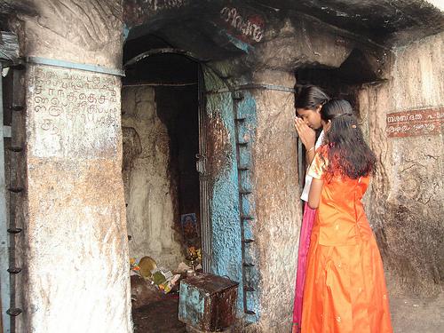
There are two important Shiva temples in Thirunandhikarai: Thirunanthikara Nanthishwaran Temple and Thirunandhikara Cave Temple. Nanthishwaran Temple is situated on the river banks of Nandhiaaru. Thirunandhikarai is the fourth shivalayam among the 12 saivite shrines in Kanyakumari district (1 Tirumalai, 2 Thikkurichi, 3 Thirparappu, 4 Thirunandhikkarai, 5 Ponmanai, 6 Pannippagam, 7 Kallkkulam, 8 Melancode, 9 Thiruvidaicode, 10 Thiruvithamkode, 11 Thiruppanticode and 12 Thirunattalam). There will be a marathon run by saivite devotees from shrine Thirumalai, the first shivalayam, to the twelfth, Thirunattalam on the day of Shivratri. The traditional Shiva temple also houses shrines for Lord Shiva and Lord Vishnu.
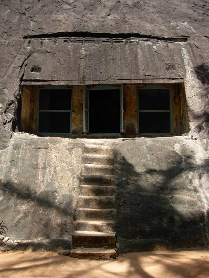
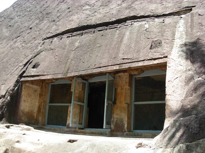
The south facing Thirunandhikkarai rock cut cave temple is excavated on the southern slope of the hillock and therefore the cave lies in an east-west orientation. The cave floor is formed 4 m above the ground level. A flight of ten steps (including the two steps provided later by Archaeological Survey of India (ASI), leads to the cave. Eight steps sculpted on the (mother) rock slope. The facade is 4.97 m in the north-south and 0.51 cm in the east-west directions. The evenly leveled rock ground is 5.68 m in the east-west and 64 cm in the south-north directions. The finely leveled rock floor is formed 4 cm above the rock ground and measures about 52 cm in the south-north and 5.40 m in the east-west directions. The upana is sculpted 5 cm above the rock floor and runs from east to west.
The facade is 4.97 m in the north-south and 0.51 cm in the east-west directions. It consists of two massive pillars in the middle and two pilasters on the corners. The pillars and the pilasters are square-kattu-square in shape. The plain angular potikas (corbels) support the slender uttira (beam). and there is no vajana above uttira. The rough rock brow forms the kapota (not designed well). The canopy of the kapota is flat. and do not incline downwards. Above the brow there are two rectangular sockets. There are also two sockets on the rock floor. These four sockets suggest the chances of forming temporary shed (பந்தல்). One meter above the kapota, bhumidesa is indicated with grooves and carvings.
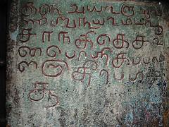
The mother rock excavated well from top to down to match slopes of the hillock. The western wall is 1.97 m in height and 1.04 m in width and the eastern wall is 1.89 m in height and 1.19 m in width. There are two 1.54 m tall (shallow) niches on both the walls and Vettezhuthu inscriptions.(வட்டெழுத்து கல்வெட்டுக்கள்) are inscribed. The Vattezhuthu inscription on the 82 cm wide eastern wall is damaged and the other inscription on the western wall is intact. The upper square, kattu and part of lower square of the western facade pillar bear another Vettezhuthu inscription.
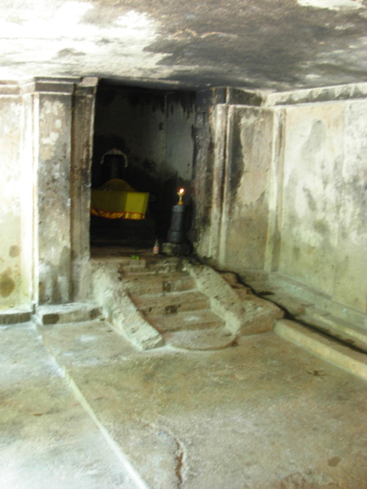
The facade leads to the rectangular mukha-mandapam which is 0.86 m in the north-south and 3.28 m in the east-west directions and 2.23 m in height. The inner-mandapam floor is raised to 0.6 cm in height. The mukha-mandapam floor is evenly sculpted. The plain eastern and western walls of mukha-mandapam show prastara components i.e., uttiram and vajanam between wall and the roof. The vajana is running through out the mandapam. The inner-mandapam on the rear is 5.40 m in east-west and 2.42 m in north-south directions and 2.18 m in height. Two square pilasters on either side of the cave walls of the inner-mandapam are supporting the uttira. The walls are plain. The roof of the mandapa is well formed.
The square sanctum is 2.16 m in all the four sides and 2.17 m height,. The walls and roof are plain. The Shiva Lingam is instituted in a socket pit which is 70 cm in east-west and 1 m in north-south directions. The square avudai is 82 cm in north-west and 78 cm in east-west directions and 0.53 cm in height. The external faces of avudai is embellished with padhabandha adishtana with components such as jagadhi (ஜகதி), octogonal kumudam (குமுதம்), khantam with pada flanked by kampa and without patiikai. The rudra bana is 44 cm in height. A small pit is shown towards north to receive the anointed water. A water chute is seen running up to the north wall and east wall of the sanctum and continued in the east wall of the mukha-mandapam.
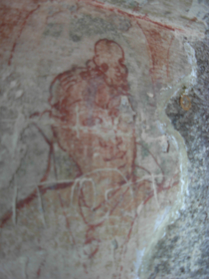
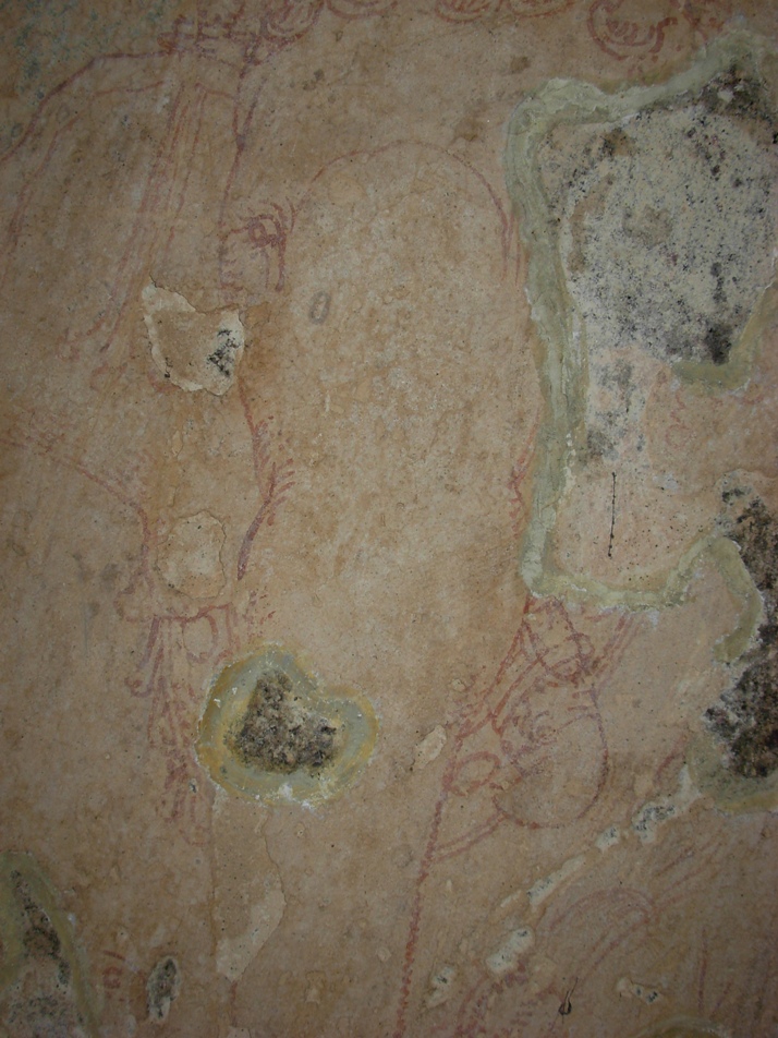
The northern wall of the inner-mandapam is washed with stucco coatings (sudhai) and painted with mural paintings. The mural paintings are considered as important since paintings belongs to earlier phase of Kerala mural art. The line paintings include the human figure with folded right hand on the chest and wears necklace with dollar. The right leg is folded and rested on the seat. The left leg could not be viewed.
The Ganapathy image is sculpted on the western wall of the mukha mandapam. The Lord wears Karandamakutam with head band, yagnopavitha, armlets and bracelets. The right rear-hand holds broken tusk, right fore-hand holds an unknown object, the rear left-hand holds sugar cane leaves and the fore-hand is damaged. The left tusk is visible and the right one could not be seen. The Vidyadharar is seen above right hand corner of Ganapathi. The flying figure holds a flower.
History:
Ay dynasty ruled the land between Nagercoil and Thiruvalla and Vizhinjam, The Ay Kingdom located to the south of Chera kingdom "functioned for long as an effective buffer state between the declining Chera kingdom and an emerging Pandya Kingdom." Ay dynasty was later known as Venad (வேள்நாடு / வேணாடு) dynasty. This land was also the scene of many battles. In 788 A.D, Vikramaditya Varaguna (885–925), an illustrious Ay ruler ruled Venad.
Jatilavarman Parantaka (Maranjadayan) the Pandya king waged a war over Ay kingdom and encircled Vizhinjam port. The Pandya conquered the Ays and made it a tributary state. Still the Ays refused to submit and fought against Pandyas for almost a century. Despite frequent defeats Cheras continued to exist as a fighting force. During ninth century Cheras rose again as a notable power. This region came under Cheras during the reign of Bhaskara Ravi Varman Tiruvadi (978 - 1036 A.D.). Rajaraja Chola I waged a war against the Venad ruler and captured the southern region and named it as Rajaraja Tennadu. Muttom is the fishing village in Kalkulam taluk. Rajaraj Chola I named it as Mummudi Chola Nallur.
The department of archaeology was started under the initiative of Professor Sundaram Pillai and the then Maharajah of Travancore, Moolam Thirunal Rama Varma sanctioned the monthly grant of Rs. 50.00 for its functioning. The renowned epigraphist T. A. Gopinatha Rao was employed as first Superintendent in the year 1908. T.A. Gopinatha Rao edited and published The Travancore Archaeological Series (T.A.S.) from 1910. Thus T.A.S. inaugurated the systematic survey and collection of inscriptions in the erstwhile Travancore state. The scholar also visited Thirunandhikarai and Chitharal caves in 1920-21 and copied and recorded the inscriptions from the caves. .According to T.A.Gopinatha Rao, the cave temple was built during the reign of the king Vikramaditya Varaguna. Chitharal was erected at Tirucharanam at the behest of a Jain priestess called Muttavala Naranakuttiyar, who also presented the temple a metallic lamp stand and a golden flower. Rao also believed that Thirunandhikkarai rock cut cave was excavated by Vikramaditya Varaguna, the Ay ruler in 9th century A.D in simple Pandya style. The rock cut caves were the founding caves of Jainism. Thirunandhikarai cave also served as dwelling place to Jain ascetic Veeranandi, who came from Thirunarunkondai Melappalli and preached Jainism during 8th century. One more cave temple Kurathiarai was also excavated in the ninth century when this region was under the influence of Jainism. Thirunandhikarai rock cut cave is under the maintenance of the Archaeological Survey of India (ASI).
Inscriptions:
This cave has four Vattezhuthu (வட்டெழுத்து) inscriptions (Travancore Archaeological Series (T. A. S.) vol. I., p. 413.) inscribed one on each side of the entrance and others on each side of the pillars. One of which bears the name of the ruler and his regnal year. The inscription, dated in the 18th regnal year of Rajaraja Chola I (முதலாம் இராஜராஜ சோழன்) found on the western cave wall, registers the gift of Muttom (முட்டம்), the village (name changed as Mummudi-chola-nallur மும்முடிச்சோழநல்லூர்) in Valluva-nadu (வள்ளுவநாடு) under Rajaraja-thennadu (இராஜராஜ தென்னாடு). The gift was made for the celebration of a festival for Mahadeva of Tirunandikarai (திருநந்திக்கரை மகாதேவர்) and also for ablution of the deity in the river, on the Satabhisha, star (சதய நட்சத்திரம்) day in the Tamil month Aippasi, (ஐப்பசி) (October - November) in the year 1003 A.D, being the birthday of the king. Records a provision made by the king for supply of one nazhi (நாழி) measure ghee every day for lighting the perpetual lamp in the name of Rajaraja Chola I in the temple.
Inscription Travancore Archaeological Series (T. A. S.) Vol. III, pp. 200-203 inscribed on a pillar, whose date assignable to eight century A.D., records the gift of 'Ur' (ஊர்-a village). For this purpose one Dhaliyazhavan (தளியாழ்வான்), along with the 'elders' of Tirunandikarai (திருநந்திக்கரை பெருமக்கள்) assembled in Kurunthambakkam (குருந்தம்பாக்கம்). The assembly converted the Ur's name into Sri Nandimangalam and gifted to one Nambi Ganapathi (நம்பி கணபதி) for purposes of mid-night offerings (நள்ளிரவுத் திருவமுது) to the Lord of the temple. The four boundaries (எல்லைகள்) are cited for the village under gift and include a river (name not known) (ஒரு பெயரற்ற ஆறு), Nandhi river (நந்தியாறு), Mudukonur (முதுகோனூர்) and Pakkamangalam (பாக்கமங்கலம்). Gopinatha Rao, who copied and recorded the inscription, has pointed out the present existence of Mudukonur and Pakkamangalam near Nandhimangalam.
Inscription Travancore Archaeological Series (T. A. S.) Vol. III, pp. 203-206 comprising 40 lines was inscribed on another pillar. This inscription records the gift of land by Mangalacheri Narayanan Sivakaran to Tiruvallavazh Mahadevar of Tirunandikarai (திருநந்திக்கரையில் உறையும் திருவல்லவாழ் மகாதேவர்). The inscription lists out the land pieces. Resolved the wages to be issued from the land produce accrued from the above land: four measures (கலம் Kalam) to Santhipuram, five measures (கலம் Kalam) to Uvachar (category of temple staff), five measures (கலம் Kalam) to Udayar (category of temple staff) and cleaning staff as well as for puja rituals, The perpetual lamps were lit using 60 measures (uri - உரி) of ghee from the remaining land produce.
Road Transport : Thirunandhikarai and its nearest town Kulasekaram are well connected from Thirvananthapuram or Kovalam Beach or Kanyakumari. You can get busses from Nagercoil, Thuckalay, Marthandam, Kulasekaram. Kerala Tourism Development Corporation (KTDC) organizes local site seeing tours.
Nearest Railway Station is Marthandam. Nagerkoil railway station is 15 km away. Kanyakumari railway station is connects with major cities in India.
Nearest Airport is Trivandrum International Airport.
Reference
- A topographical list of the inscriptions of the Madras presidency (collected till 1915) with notes and references by Rangacharya, V. (Vijayaraghava); Archaeological Survey of India 1919
- Kerala State Archaeology Department (Wikipedia)
- On the southern tip of India, a village steeped in the past. The Hindu November 17, 2011
- Thirunandikkara Cave Temple in Thirparappu in Kanyakumari. Yatra to Temples.com (http://www.yatrastotemples.com/thirunandikkara-cave-temple-in-thirparappu-in-kanyakumari/)
- Thirunanthikarai (Wikipedia)
- Thirunanthikarai Cave Temple. C.P.R. Environmental Education Centre, Chennai. (http://www.cpreecenvis.nic.in/Database/ThirunanthikaraiCaveTemple_2939.aspx)
- Thirunanthikarai Cave Temple. Tourmet.com (http://tourmet.com/thirunandhikarai-cave-temple/)
- Thirunanthikarai inscription. Kerala Culture.org (http://www.keralaculture.org/thirunanthikara-inscriptions/366)
- திருநந்திக்கரைக் குடைவரை இரா.கலைக்கோவன், மு.நளினி வரலாறு.காம் இதழ் 63 (செப்டம்பர் 15 - அக்டோபர் 15, 2009)